Sunday, 25 September 2016

Stanage Struggle

From the Stanage Stuggle website 2011
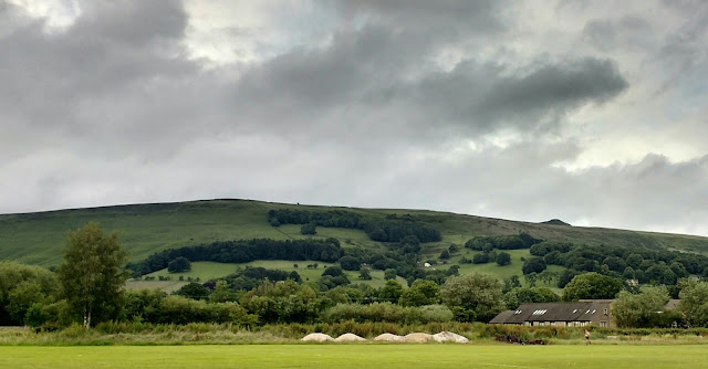
 It was the picture above, or one just like it, that alerted me to the fact that these races were even going on across the peak district.  I was still pretty much a running novice at this stage, running at lunch times with a couple of road 10k events behind me.   The guys I was running at work with were pretty much road runners, but with my son playing football in Wirksworth, I had managed to hear about and take part in their Stuart Learmouth Undulator, which I had loved.

Not sure how I came upon the picture above but it spoke of something a bit more out of the ordinary, a bit more out in the wild.  I liked the fact that you can see the line of runners tailing off into the distance looking like for these runners there is still a lot of climb left to do.

So I did this race in 2014, signed up on the day, for a fiver!! and it was fantastic.  A flatish first mile followed by a climb up to the edge, a run along the top that seemed to go for ages, a charge back down the hill and a final mile that seemed to have more up than down, especially as I'd left any energy I had remaining on the hill.

Can't remember why, but I couldn't make a return in 2015, so had it on my radar for this year.  The fact that so many of these small fell races are entry on the day is great for me, think I have a problem with long term planning and the cost is in most cases very reasonable and going to local causes or school or village funds.

So this year I've made it to the lovely Hathersage, driving over the tops via Owler Bar.  My natural instinct to avoid a queue leads me to not patiently waiting to park in the field but drive through the streets of the town getting further and further away from the school before finally getting a space under the railway.  At least I then get a warm up getting back to the registration.

By the time I get into the hall there is no queue and sign on is completed in a couple of minutes. Plenty of Belper Harriers out on what is a fabulous day weather wise, with blue skies and sunshine on a warm September day.  As an added bonus, son number one has made the bus trip from Sheffield and is there to meet me.

Time for a bit more of a warm up and a trip to the Hathersage's public toilets, and let me just take time to say that, I am fully prepared to pay double next year as long as the extra money goes into the replace that toilet block fund.

Back into the fresh air and down to the start where we had a pistol to see us off.  First mile does give plenty of time for the field to sort itself out before the climbing starts, so no need to push the pace too much.  You get a great view of Stanage Edge during this time which does seem some distance away but its good to have the objective in sight.

The climb takes in tarmac, steps, a field and woods before a single track sandstoney path works it way up to the ridge.  Two years ago there was a short bit of walking time as the runners bunched up near the top, so I've pressed on this year expecting some of the same, but as it turns out there is no rest bite and its straight up and on to picking my way along the sandstone edge.


Not much traffic along here, unlike last time, and I find a bit of time to take in the amazing views that are all around at this point.  A quick check behind me even tells me I've enough time to quickly whip out the phone and get a shot or two on the run.


The picture on the right shows the drop off point from the edge which sees the start of the down hill back to the village.  Single track at first, with not many passing places so there is a chance of getting caught behind or holding others up, but once over a stile there is plenty of space to pick up the pace or let others pass.


All the walkers encountered on the way down were extremely generous, seemingly not minding at all their walk being interrupted by a sting of vest clad runners zipping through the countryside, even holding gates open and offering encouragement.

Remembering last time, I've kept enough back for the run through the fields and back up to the church before the final run down the road to the finish.  No sprint to the line needed today as I've enough distance between me and the runners behind and no chance of catching those in front, honest.

A bottle of water, some prize giving and a roast pork roll at the Pool cafe follows, chewing over the race with fellow Harriers, including Alan Billington, who took the fab shot below.  Strikingly similar to the one at the top, except this time there's me in the race, fantastic, thanks Alan.


Thanks also to the Fat Boys Running club for putting on such a lovely event and the fabulous marshals.  Would I do it again? Yes, how about next year.

Wednesday, 7 September 2016

Totley's exterminator


I've just had a check and a fair bit of this fell race isn't actually in Derbyshire but I'll carry on regardless.

Decided a while back to try something a bit further than I am used to, and having missed the half tour of Bradwell settled on the 'Exterminator', a fabulous looking route through some of the western most areas of the peak district.  I felt I knew some parts of the route already, Stanage Edge, Padley Gorge and the Longshaw Estate, whilst some areas would be new to me such as Totley Moor and Mitchell's Field.

I felt that with my partial knowledge and some studying of the route from afar, I would be ok in amongst the other runners, figuring the bit I knew the least about would be covered whilst the runners were all still in reasonable close proximity.  Armed with my checked, mandatory kit, map of the route and instructions I was ready to go.


The weather forecast was for fine, dry weather but the skies over Matlock and Bakewell on the way over promised anything but, with a blanket of thick black cloud covering the Derwent valley towns. Totley itself was in under blue skies though the low lying rainbow on the horizon promised something different.


The climb up to the trig point on Totley moor (CP1) was taken at a steady enough pace, with the leaders already disappearing into the distance and sure enough I was able to follow the line of runners off the hill and down to the stepping stones (CP2), taking some routes I certainly would not have picked out had I been on my own. 


After the climb up to the road had been completed, I had managed to find myself a fair way behind those in front of me so decided to push on up through Houndkirk Moor and onto Burbage Moor.  The narrow paths though the heather were again, not on the original route plan I had in my head, but I managed to tag onto a few other runners by the time we dropped over the rocks and headed to Higger Tor.


Keeping it nice and steady over Higger Tor to CP3, some water and a Jelly Baby, the route then took us up onto Stanage Edge.  Although the clouds still looked a bit threatening the rain was holding off and the temperature was good.  CP4 was duly reached and we were shown our route off the rocks and into the bracken.  Could have picked a better route down here I'm sure.  Looking at google earth there do seem to be some tracks through but I struggled to find them and was off my feet twice on my way to the bottom.

Some nice steady running was then ahead taking in some of the Stanage Struggle route to the Church at Hathersage.   Another water and Jelly baby at CP5 and a fellow runner asking me if I was ok? which was nice of him, thought I must have been looking a bit tired or something.  A bit more climbing up to and beyond CP6 at the far end of Mitchell's field saw me drop a couple of places before starting a long slow decent to the familiarity of the pump station at bottom of Padley Gorge.

I'd managed to fall behind those ahead of me at this point and rather than wait for a few seconds for those behind I set off from CP7 on the route that I had worked out before hand, down to Grindleford station and then taking the path up into Longshaw.  Now I still say this doesn't look to bad on the map but the height loss and subsequent gain I had to make, meant I found myself on a route with no other runners, and the climb up the steep ascent into the National Trust estate was taking it toll on my legs. Combine that with missing the planned entry point, then running what ended up being three sides of a square instead of one, my decision to not hang around for someone who knew what they were doing was proving to bit of a minor disaster.

Looking back I was pretty cross with myself for the amount of time and places I lost because of this, and the extra distance was telling as my pace slowed to a walk once up on White Edge Moor.  It was however, quite interesting to be in a race but out there on my own cutting through the acres of purple heather.


No runners in sight, either back towards Longshaw...
...or ahead towards white edge.


The Skies were becoming much brighter as I made my way back onto Totley moor and up to the trig point again, finally joining up again with some other runners approaching from the other side, all moving better than me at this stage. Thankfully the return back down to Totley was all downhill and I managed to get back to the Cricket Inn without losing any more places, but felt the lap of the sports field was a little uncalled for.  I was shattered.


Post CP8 performance aside, a cracking event through some magnificent scenery and with the heather still out in force it was fabulous views all round.  Lovely roast pork bap and cake at the finish made me feel a bit better as well.  Found the guy who had shown concern for my health back in Hathersage and thanked him.  I had only noticed later in the run that my knee and shin were covered in blood, almost certainly a result of my descending technique off Stanage Edge.

Would I do again?  Certainly, but may get in a recce of where I went wrong  before my next attempt.

My route


Saturday, 20 August 2016

Linacre Handicap / Linacre Woods

It was two and a half years ago when Steve, John, Jonathan and Andy set off on the inaugural Linacre Handicap.  To be fair its not quite had the same impact as Parkrun, two runners last month, three this, but it is still going through sun, wind and rain and I'd say snow but I remember having to call it off once after heavy snowfall brought traffic chaos to Chesterfield and shut Brampton Manor.


I first discovered the Reservoirs a short while after I had taken up running.  At that time I had to take the car up to the little lay by, just after Ashgate Hospice and run from there. There wasn't much chance of me getting up, around and back to my office on Old Road.  Now its a regular feature on my lunchtime runs.


The handicap route works out about half road, half trail taking 2k to get up the hill to the Ambulance station and on past Ashgate Hospice before an off road 5k down a track that gets some pretty big puddles after rain, to a fork which is the start point for a loop round the waters. Once back to the fork its back some of the way along the track before tuning off onto the Linacre estate and the 3k back to Princes Sports club as it is now called.


The three reservoirs each have a damn but it is just the third we cross for the race.  In addition to these there is a boardwalk walk that runs round the edge of the top reservoir that also makes a great circuit.


The track that runs around the circumference is wide and has enough stone on it to keep the mud at bay in most places all year round, I never feel the need for trail shoes apart from maybe one short section which becomes a bit of a bog in the wetter weather.


Running at least once a month round the parkland you get to see the variety that the different seasons bring.  Whilst spring brings all the fresh greens and summer its challenging warmth the colours of autumn and winter can be breath taking.


We currently run on race on the third Wednesday of each month with the the handicapping aiming to to have everyone finish at around the same time.  Sometimes it works really well and we have had some really close finishes on the Brampton Manor drive sometimes its a lot more clear cut but it does mean that anyone can win it and hold the trophy for a month.


Obviously its a bit restrictive being on a lunchtime, but if anyone reading this fancies joining us you should let me know.  Whilst I'm still running it, am happy to have new runners joining.

Linacre Handicap Route on Endomondo


I feel very fortunate to have such a lovely environment to get to for lunchtime running and there are some terrific routes to be had in and around the parkland.


Monday, 18 July 2016

Manifold Valley, Evening Rab Mini Marathon


Having done my first of these in Dovedale earlier in the year, I was fortunate enough to be able to team up with our Joel for this event around the Manifold valley.  The rain, as forecast, had moved away by the time we arrived, some time after six, to a well organised registration and a friendly relaxed atmosphere.

We took the opportunity to unload any kit we didn't need and had a little study of the map on the board (without the check points) just to give us an idea of what to expect.  Initial thinking was that we would be making our way down the Manifold track to start with but once we had taken our starters orders and checkpoint map it looked like the Wolfscote Dale side might be a bit more rewarding a decision which in hindsight was a good one.

After a bit of a road start and ticking off the first marker we headed off to number sixteen, a decision which in hindsight was not a great one.  At first it was boggy, then extremely boggy and then steep with the dibber station on top.  And then we came back down pretty much the same way as we went up.  Looking back later we could see we could have picked this one up later without so much climb involved.

Great views though...
 
Once off the hill we worked our way around to Wolfscote Dale itself, picking up another check point before running down this very pretty valley towards points thirteen and twelve.  The close proximity of these two suggested interesting times and sure enough they had been placed about as high above either side of the valley as they could have been with a river crossing to make between them.

After that had all been completed we ignored another check point and made our way over to the other side of the map already eating into our second hour.

Having aimed first for number four up the climb next to Wetton Hill we then took time to assess what we could achieve in with the rest of the time, pausing as well to appreciate the terrific 360 degree views we had.
We reckoned on three more dibs on the way back could be done and we set off down the tussocky slopes, appreciating the fact that we weren't trying to climb up this way.
Picked up the first two of the three we arrived at a t-junction.  Eight minutes of the two hours remaining, the finish to the right and a 10 point checkpoint to the left Joel persuades me that, for the banter, the extra points is the way to go.  As we only arrive back late back at the finish by under 4 minutes this gives a net gain of six points for the effort..

A great selection of cakes greets us at the end, rhubarb, lemon drizzle, raspberry meringue, flapjack and a fabulous gooseberry sponge. The results are also in and we can see that we are in the top ten by three points.  Great call Joel!

Thoroughly recommend these events,  really enjoy the additional challenge of the navigation and the extra freedom of route choice and being able to stop every now and then without the feeling of losing places that you would have in a straight race.  Looking forward to the next one.

Endomondo route is here

Results  make a great read post event as you can see all the different routes people took and how they got on.

Monday, 4 July 2016

Kedleston Hall

Apart from the odd drive through, I've not spent much time at Kedleston Hall, probably in the main because they like to charge £5 once you get out of the car so the whole of the estate falls under the entry fee. But with the family National Trust membership that was given us this year in place and Kedleston being our nearest major NT property we are trying to make the most of it.


If you take in all the trails then you can probably get a six and a half mile route out of the estate but Sunday's run just took in the long walk and the lakeside walk.  Once away from the house area it was pretty quiet even for a Sunday and there's plenty to look at on the way round.  The long walk has a gentle climb before levelling out all on a tree lined path, nice and shady in the summer, with some great views of the house before dropping down towards the lakes. Don't miss the path down to the splash pool.
Route on Endomondo

Didn't see any otters otters or kingfishers this time but plenty of cows, sheep, geese, coots and even some oyster catchers, can't believe there's any oysters to be caught there though.  Next time definitely take in the wilderness walk and take it out into the surrounding countryside as well.  Really lovely place for a picnic as well.
I understand that the jog club go there or did go there once a month which sounds like a great idea.


Saturday, 2 July 2016

Hope Wakes Fell Race 2016

Having been told this was a 'not to be missed' event I was pretty gutted that work had organised an upgrade for me on the evening of this race, but as 5:15 approached I had news that the project had been postponed and my evening was sorted.  Managed to finish what I was doing by twenty past six and as I was in Chesterfield had plenty of time to get across to Hope with 20 minutes to spare.
 
View from the start with the top of Win Hill just peeping out above the farmhouse.
Although it had been raining most of the day the forecast and indeed the weather for the evening was fine, bit of threatening cloud but also some occasional sun.  Six other Belper Harriers who had made the trip were already signed in and warming up amongst the other runners and puddles. No problems with parking and registration was very well organised and quick leaving enough time for warm up and a crucial reccie of the finish.

Quite a bit of tarmac at the start which I'm not a big fan of but the pack was nicely thinned by the time we got onto the fields.
After that its a clockwise run round round with two significant climbs and a fast finish back to the sports ground.

Had finally managed to get some fell shoes which certainly helped through some of the muddier sections especially in the woods where the wet weather had certainly taken its toll and I really warmed to them on the descent where they proved to be very stable.

First incline passed by without too much event before what proved to be quite a long passage through the forest with glimpses of Ladybower reservoir on the left.

Would have been nice to have stopped to take in the view here and on the way up Win Hill, but a quick glance round as we made our way through the heather prompted me to take out the phone.  The going was hard but slow so no time lost in taking a quick photo.  The reward for the hard work in getting to the top was instantaneous with a fantastic view across a sunlit Hope valley.
Route on Endomondo
After that it was all down hill to the finish and unlike my previous outing at Edale, I managed to hold on to my position and even work my way past a few people once we got to the open fields.  Managed to spot the finish before the last couple of stiles and chose to jump the mini ford instead of crossing the wooden bridge.  Having been across it earlier I knew new trainers were nearer to ice skates on the wet wood.

Loved the evening and really enjoyed the route,  would be great for a walk or run.  Hope to be back next year.  Credit to the organisers, marshals and helpers, quick registration and the first set of results seemed to be going up as I finished.  


Tuesday, 21 June 2016

Kinder from Upper Booth


Inspired by a recent visit to Edale for the Fell race I returned for a Father's day walk up to Kinder Downfall and back round via Grindslow Knoll.


We parked in the parking area on the road to Upper Booth ("You are here" on the map) and then continued up the road on foot to pick up the Pennine way.   There's more spaces in Edale itself with toilets, cafe and pubs but this suited us nicely and we called in on Edale after we had finished.

Once on the Pennine way we pretty much followed a route as shown on the map up to Kinder Downfall back across the Peat bogs to Crowden Tower before heading across to Grindlow Knoll and back down.  Just over 8 miles in total.
Route on Endomondo
The picture on the left shows the valley up which the pennine way travels before arriving at Jacob's ladder.  There's quite a number of ways to get up onto Kinder but judging by the number of people coming up and down, this must be one of the more popular.

Bottom of Jacob's Ladder


Its then quite a steep but steady climb all the way to the top but the effort is rewarded whenever a pause is made to turn around and take in the expanding views.

Once at the top we have then continued straight on up the Pennine way to Kinder downfall before turning right to follow the river into and across the peat.  This gives us two very different aspects of Kinder.  On the way out we are amongst the rocks and boulders and have fantastic views to the left down to Kinder reservoir, and on the way back we are in the gulleys, finding Christmas trees and  hopping across the tufts with only one of us temporarily losing a leg to the marsh. 

After reaching Crowden Tower instead of taking one of the routes straight down we've turned left and headed off to take in Grindlow Knoll which was well worth it if only to have a look at the route taken by the fell race the previous week.  From there it was across the plateau on a grassy path before a steep descent back onto the Pennine Way.  Lovely days walking and lots of route choices so its easy to be flexible when you are up there.  And, the rain started just as we were walking down the lane back to the car, perfect.


Approaching Crowden Tower

Views from the top of Kinder Downfall